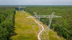
Computer-Vision Drone Inspector for Transmission Lines & Wild-Fire Risk.
Live Registration
BATCH #24
03Seats Left
92% Booked
02
Days
:
00
Hrs
:
00
Min
:
00
Sec
Course Overview
Limited SeatsClosing Soon
Computer-Vision Drone Inspector for Transmission Lines & Wild-Fire Risk.
Professional Certification Program
🎥
FormatLive + Recorded
📅
Duration8 Weeks
📜
CertificationVerified
Program Syllabus
Module 1
About This Course
This workshop trains participants to use drone-based computer vision for inspecting transmission lines and assessing wildfire risks. It covers data capture, flight planning, model development for defect detection and vegetation encroachment, and risk mapping, enabling participants to generate actionable reports for improved safety and decision-making.
Module 2
The aim of this workshop is to teach participants how to use drone-based computer vision for inspecting transmission lines and assessing wildfire risks, covering data capture, model development, and integration of risk mapping for actionable insights.
Aim
Module 3
*]:pointer-events-auto scroll-mt-[calc(var(–header-height)+min(200px,max(70px,20svh)))]” dir=”auto” data-turn-id=”request-WEB:2d0bd553-affd-4c19-860e-dcc242b17a36-11″ data-testid=”conversation-turn-24″ data-scroll-anchor=”true” data-turn=”assistant”>
Workshop Objectives
Module 4
Workshop Structure
Module 5
📅 Day 1 – Foundations & Data Capture
- Mission scope: defects, vegetation encroachment, wildfire ignition cues
- Platforms & payloads: multirotor vs fixed-wing; RGB/thermal/multispectral; radiometric & geo calibration
- Flight planning & compliance: geofencing, BVLOS limits, safety near energized lines
- Data & labels: imagery/video, orthos/point clouds; annotation schema & severity tags
- Hands-on: Plan a corridor mission (flight lines, camera settings) and produce a data-collection checklist
Module 6
📅 Day 2 – Computer Vision Pipeline
- Preprocessing: sync/geotag, deblur/distortion, tiling, class balance
- Models: detection/segmentation for hardware & insulators; vegetation encroachment; thermal hotspot flags
- Robustness & evaluation: glare/motion/scale, active learning; precision/recall, per-class AP, uncertainty gates
- Hands-on: Fine-tune a compact detector+segmenter and export inference (boxes/masks) with a defect/encroachment summary
Module 7
📅 Day 3 – Wildfire Risk & Operations
- Risk layers: fuel dryness, slope/aspect, weather/Red-Flag indices, proximity to lines, prior ignitions
- Fusion & workflow: combine CV outputs with terrain/weather; triage queue, human-in-the-loop, CMMS ticketing
- Deployment: edge vs cloud inference, bandwidth limits, encryption, model drift/rollback
- Hands-on: Build a corridor risk map and generate a one-page report with geotagged findings, risk ranking, and actions
Module 8
Who Should Enrol?
-
Professionals in electrical engineering and infrastructure maintenance
-
Researchers in wildfire management and environmental monitoring
-
Individuals working with drone technology, computer vision, or data analytics
-
Those involved in transmission line inspection and vegetation management
-
Professionals focused on wildfire risk assessment
-
Basic knowledge of drones and computer vision recommended but not required
Module 9
Workshop Outcomes
-
Proficiency in drone-based data capture for transmission line inspections and wildfire risk assessment.
-
Hands-on experience in developing and fine-tuning computer vision models for defect detection and vegetation encroachment.
-
Ability to integrate computer vision outputs with environmental and wildfire risk layers.
-
Skills to generate actionable risk maps and operator-ready reports.
-
Enhanced understanding of flight planning, compliance, and safety protocols for drone operations.
Module 10
Fee Structure
Module 11
Student
₹1999 | $65
Module 12
Ph.D. Scholar / Researcher
₹2999 | $75
Module 13
Academician / Faculty
₹3999 | $85
Module 14
Industry Professional
₹5999 | $105
Module 15
What You’ll Gain
- Live & recorded sessions
- e-Certificate upon completion
- Post-workshop query support
- Hands-on learning experience
Module 16
Join Our Hall of Fame!
Take your research to the next level with NanoSchool.
Module 17
Publication Opportunity
Get published in a prestigious open-access journal.
Module 18
Centre of Excellence
Become part of an elite research community.
Module 19
Networking & Learning
Connect with global researchers and mentors.
Module 20
Global Recognition
Worth ₹20,000 / $1,000 in academic value.
Module 21
View All Feedbacks →
Need Help?
We’re here for you!
★★★★★
Scientific Paper Writing: Tools and AI for Efficient and Effective Research Communication
GEETA BRIJWANI • ★★★★★
Scientific Paper Writing: Tools and AI for Efficient and Effective Research Communication
Kevin Muwonge • ★★★★★
AI Applications in Pharmacy: Leveraging Technology for Innovative Healthcare Solutions
Ankita Srivastava • ★★★★★
AI-Powered Multi-Omics Data Integration for Biomarker Discovery
Abdul Mueed Hafiz • View All Feedbacks →
